" P Yates"
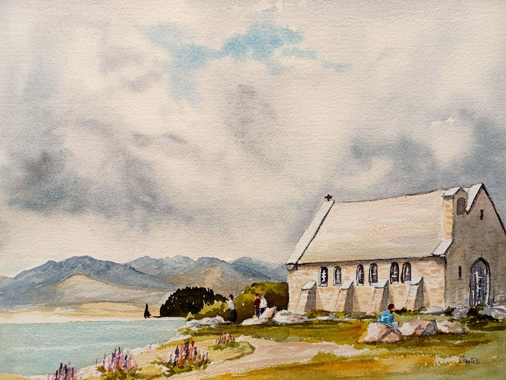
The Church of the Good Shepherd on the shores of Lake Tekapo on the South Island of New Zealand is a small Anglican church used by various denominations. Built in 1935 as a memorial church to commemorate early settlers, it is one of the most photographed items in the country. It has a Category I heritage registration by Heritage New Zealand. Walter Ernest Detheridge Davies became the vicar of Fairlie in February 1933. The Fairlie cure extended up to Mount Cook Village and Davies realised that the Mackenzie Basin needed its own church; he first suggested this to parishioners in September 1933. Davies also suggested that a large window should be incorporated so that there would be a view from within the church of the lake, based on the 1930 design of St James Church at Franz Josef on the West Coast. The idea was taken up by various local runholders who thought that it would be an appropriate way of acknowledging and commemorating their pioneering ancestors. The land for the building was given by the owners of Braemar Station, which is (mostly) located on the eastern shore of Lake Tekapo. A generous amount of land belongs to the church so that the building will continue to be sited on its own. Esther Hope, a local artist from Grampians Station, provided sketch designs for the proposed church. The Christchurch architect Richard Strachan De Renzy Harman (1896–1953) based his 1933/1934 design on Hope's drawings.The bell commemorates Audrey Barker (died 1935) and her grandfather Edward Sealy The foundation stone for the church was laid by Prince Henry, Duke of Gloucester, on 16 January 1935, in the presence of the bishop of Christchurch, Campbell West-Watson, and vicar Davies.The building committee had decided that the church should blend into the environment. The grounds surrounding the church were deliberately left with their native vegetation. The church was clad in local stone and lichen was left on the stone to give it a natural look. The structure itself was made from concrete, with the stones as cladding. Fred Trott won the construction tender, but the work was carried out by Les Loomes and Doug Rodman; the latter was engaged to Trott's daughter. The stonework was done by Christchurch stonemason Jack Miller. A Christchurch firm installed the hardwood shingles. Audrey Barker had died in February 1935 aged 21, and the Barker and Sealy families donated the bell for the church, commemorating both Audrey Barker and her grandfather, Edward Sealy, who had explored many of the glaciers in the area during the 1860s. The bell was cast in Christchurch by W. H. Price and Son Ltd. The dedication ceremony was held on 3 August 1935 by the Bishop of Christchurch.The whole effect of the little church is striking and has won the admiration of all who have seen it.Rodman, one of the two builders, was the first person to get married at the church. On 14 December 1935, he married Peggy Trott.
The Australian oak shingles did not last in the harsh climate of the Mackenzie Basin and in 1957, the roof was covered with slate shingles instead. On 5 September 1985, the building was registered by the New Zealand Historic Places Trust (now Heritage New Zealand) as a Category I structure, with register number 311. The Church of the Good Shepherd is one of the most photographed items in New Zealand; photography within the building is no longer permitted as it interfered with worship. In late 2017, a fence was installed around the church grounds after "damage to the environment around the church, verbal abuse of staff, and tourists interrupting the church services". Access is granted during daytime hours.As of 2018, the local vicar estimates that 600,000 people visit the church per year.
Lake Tekapo (Takapō) is the second-largest of three roughly parallel lakes running north–south along the northern edge of the Mackenzie Basin in the South Island of New Zealand (the others are Lake Pukaki and Lake Ohau). It covers an area of 83 square kilometres (32 sq mi), and is at an altitude of 710 metres (2,330 ft) above sea level.
The lake is fed at its northern end by both the braided Godley River and Macauley river, which have their sources in the Southern Alps to the north. The snow melt from the Southern Alps is tinged with a light turquoise colour from the glacial silt.[2] This gives Lake Tekapo its distinctive colour. To the east of Lake Tekapo lies the Two Thumb Range with Mount Toby (2222m); Braun Elwert Peak (2086m); Dobson Peak (2095m) and Mount Maude (1797m) amongst the mountains over looking Lake Tekapo. On the western side of Lake Tekapo. Mount John (1031m) is closest to the town with Lake Alexandrina further north and Mistake Peak (1931m) sitting towards the head of the lake. Cowans Hill (783m) lies at the southern end of Lake Tekapo behind the township and next to the Tekapo river.
The average water temperature of the surface of the lake varies between a low of between 5.8 and 5.9 degrees Celsius in September and a high of 17 degrees Celsius in January. The lake is a popular tourist destination, and several resort hotels are located at the township of Lake Tekapo at the lake's southern end. The Lake Tekapo Regional Park, administered by Environment Canterbury, is located on the southern shore of the lake. State Highway 8 runs past Lake Tekapo at its southern end. On a clear day, the taller snow-capped peaks of Mount Cook National Park are visible from Lake Tekapo. An astronomical observatory is located at Mount John, which is to the north of the town, and south of the small Lake Alexandrina.Lake Tekapo is one of the sunniest places in New Zealand with annual sunshine hours averaging more than 2,400 each year.Tekapo is an incorrect spelling of Takapō, the te reo Māori name for Lake Tekapo. Takapō means to leave in haste at night. In 2021, the MacKenzie District Council announced that it will start using the dual names of Tekapo and Takapō when referring to Lake Tekapo.
The legends of Ngāi Tahu speak of Lake Tekapo being one of the lakes dug by the Waitaha explorer Rākaihautū with his Polynesian digging stick which was called Tūwhakaroria. After arriving in the Uruao waka at Nelson, Rākaihautū divided his people into two groups. Rākaihautū led his group down the middle of the island, digging the South Island freshwater lakes. His son, Rakihouia, led the other group down the east coast of the South Island. Ngāi Tahu visited Lake Tekapo and the nearby Lake Alexandrina as part of their seasonal food gathering patterns. The lakes were well known for eels and weka. These were gathered and preserved for the upcoming winter months
Motuariki is the small island in the middle of Lake Tekapo. The legends of Ngāi Tahu tell of Motuariki, who was an ancestor on the Ārai-te-uru waka that capsized near Shag Point on the Otago coastline. After the waka capsized, many of the passengers went ashore to explore the land. Legend states that they needed to be back at the waka before daylight. Many did not make it, including Motuariki, and he was instead transformed into the island of Motuariki.
Lake Tekapo and the surrounding district were recognized as an International Dark Sky Reserve in 2012. The reserve is 4367 square kilometres in size making it amongst the world's largest. The Dark Sky Reserve accreditation recognizes that the night skies are almost completely free of light pollution and ideal for star gazing.
Lake Tekapo is also known for its stunning seasonal display of Lupin that bloom along its shores from around Mid November until the end of December. Russell lupins were introduced in the Mackenzie Basin in the 1940s from sowings or lupins planted in garden which had seeds that spread widely. In 1949 Connie Scott, of Godley Peaks Station, scattered lupin seeds along the roadside after purchasing about £100 worth from the local stock and station agent. Although beautiful, they modify the ecosystems of braided rivers. There were fewer lupins around Lake Tekapo in December 2020, due to the water level in the lake being too high at a vital time in their growth cycle, causing them to fail to flower.
Drivers have been warned to take care during the lupin season, as many visitors to the area slow down or pull over to admire the lupins along State Highway 8, but this may be unsafe and create the potential for accidents.
The lake's original outflow was at its southern end, into the Tekapo River. In 1938 construction commenced on a power station, originally due to be finished in 1943 but halted in 1942 by the world war. At the same time, control gates were constructed to regulate outflows to the Waitaki Dam downstream. Work restarted in 1944, and the power station, now known as Tekapo A, came online in 1951.
Water from the lake is diverted through a 1.4-kilometre (4,600 ft) tunnel under the town to the power station, with the water originally being returned to the river. With development of the Upper Waitaki hydroelectric scheme in the 1970s, water is now fed into a 26-kilometre (16 mi) canal which leads to Tekapo B on the shores of Lake Pukaki.
Following a turbine failure in 1986, a new Kaplan turbine was installed, with a more efficient design and higher output (42 000 HP) than the original. Today, the power station produces an average of 160 GWh annually, from a 25.2 MW capacity generator. The net head of the station is 30.5 m.
In 2008 Tekapo A and Tekapo B hydro stations were refurbished following the upgrade of Benmore and Waitaki.On 1 June 2011, Tekapo A and B hydro power stations were transferred from Meridian Energy to Genesis Energy on instruction from the Government.
In February 2021, Genesis Energy finished an upgrade that strengthened the Tekapo A power station to withstand earthquakes. It involved five years of planning, two years of construction and cost $26.5 million. It was a challenging build to upgrade the infrastructure and tunnels which were built in the 1940s. The Tekapo A power station provides power to almost 100,000 homes.
On the north side of the lake, 24 km from the Tekapo township is the Roundhill Ski Area situated in the Two Thumb Range, which caters primarily to beginner and intermediate skiers. For advanced skiers, Roundhill Ski area also has the world's longest and steepest rope tow which runs to the top of the Richmond Range (2133m).
Situated on the shores of Lake Tekapo is the Church of the Good Shepherd, which, in 1935, was the first church built in the Mackenzie Basin. The church at Lake Tekapo was designed by Christchurch architect R.S.D. Harman, based on sketches by a local artist, Esther Hope. The church is one of the most photographed in New Zealand, and features an altar window that frames views of the lake and mountains.
Close to the Church of the Good Shepherd is a well-known bronze statue of a New Zealand Collie sheepdog. The statue was commissioned by Mackenzie Country residents in recognition of the indispensable role of the sheepdog in their livelihoods. The sculptor was Innes Elliott of Kaikoura, with a dog called Haig, belonging to a neighbour, being the model. Elliott reported the sculpting process took approximately fifteen months. Clay for the model came from the insulator works in Temuka, with a plaster cast of it made and sent to London in 1966, where the statue was cast.
Large brown and rainbow trout can be caught in Lake Tekapo. Trolling a lure from a boat is one option for fishing Lake Tekapo. Fishing from the shore is also possible. The best spots for fishing from the shore are to be found around the mouths of the many small streams that flow into the lake. These include the Cass River; Mistake River; Boundary Stream; Glenmore Station Tarn; Coal River and the Macauley River.[2] In 2016 the Fish and Game Council released 45,000 baby salmon into Lake Tekapo to improve fishing stocks and a further 50,000 were released in 2020. The upper half of the Tekapo Canal will be closed to fishing over the winter of 2021 to conserve stocks while spawning. The Tekapo canal is known for very large (trophy size) rainbow trout.