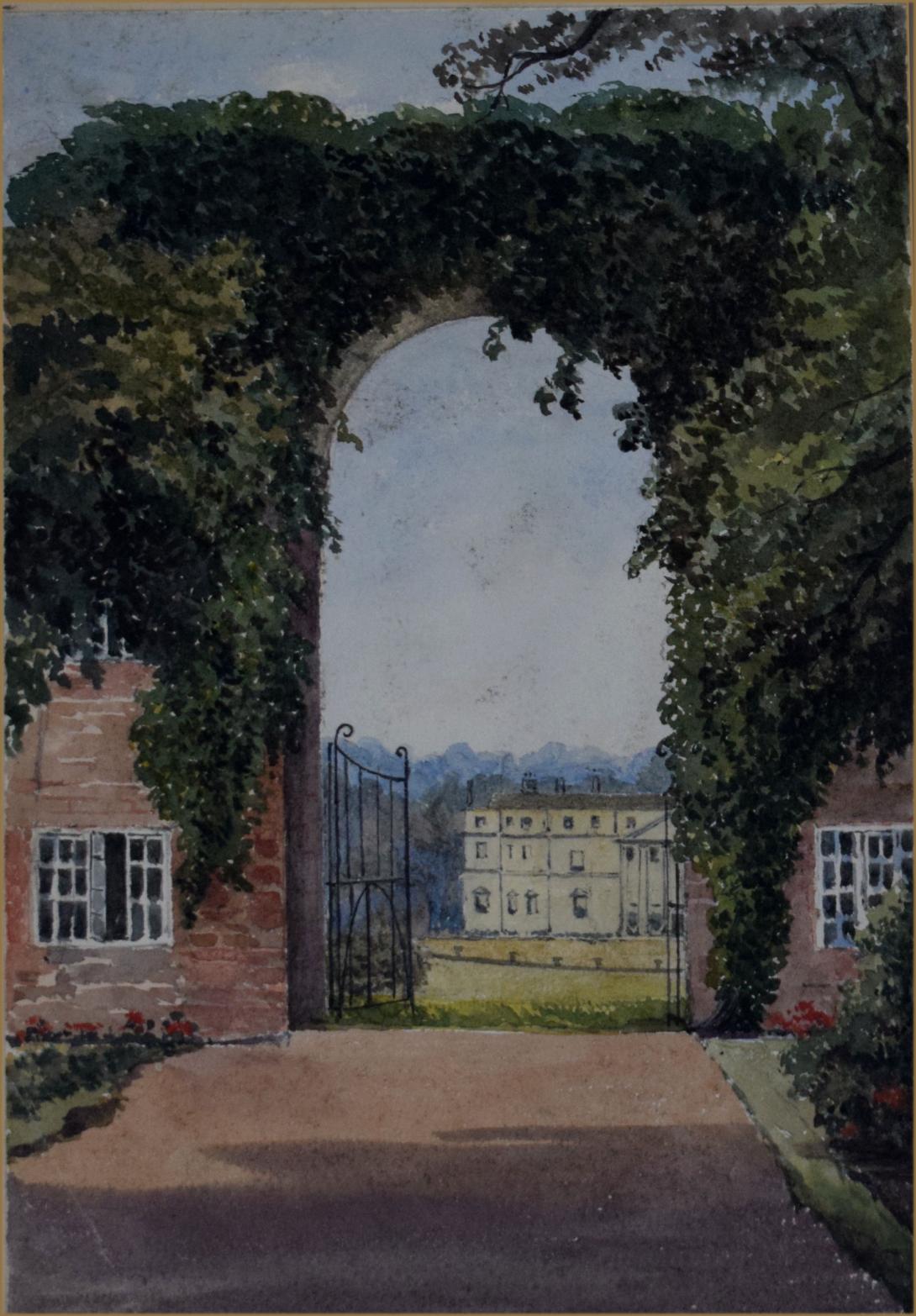
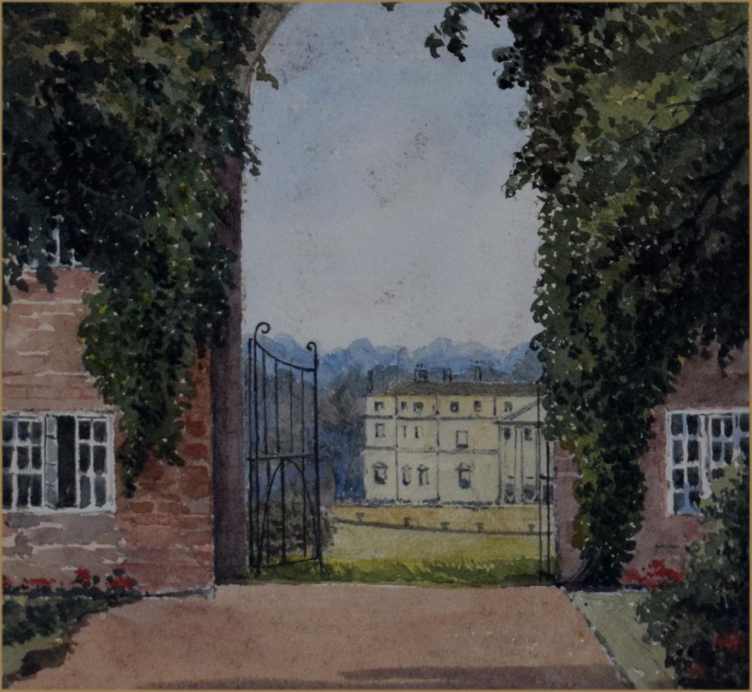
inscribed and dated in the margin " Lodge in Horton Park Northants Aug 1883"
The registered park overlies the remains of the medieval village of Horton, which lay to the south, south-east and east of the now demolished Horton Hall. The Royal Commission on the Historical Monuments of England survey of 1979, indicates an extensive settlement comprising roads, crofts and tofts south of the hall and a former pond (remodelled in the 1740s to create a landscape feature), ditched enclosures to the east and tracts of ridge and furrow cultivation across the park. Enclosure probably took place initially in 1584 when Robert Lane received licence to enclose a park with a fence and ditch taking in 200 acres (c83ha) of wood and 300 acres (125ha) of arable and pasture in the south of the parish and including Horton Woods. This park is not related to the registered landscape. To the south of the hall, the village appears to have been deserted by the early C17 and was cleared to the east in the early C18.
Formerly the property of the Parr family, in the mid-1620s, the manor passed into the possession of Sir Henry Montagu, created Earl of Manchester in 1626. An estate map of 1622 shows the Hall to have been surrounded by formal gardens at this date. Horton remained in the Montagu family until the late C18. The house was extended with a new wing by George Montagu, created Earl of Halifax (d.1739) in 1715. The Earl seems also to have been responsible for alterations to the gardens and pleasure grounds around the Hall. An illustration by Peter Tillemans in 1721 shows a formal parterre garden within a large walled court east of the Hall, which stood centrally across the court's west end. This garden was probably created when a wing was added to the hall in c1700. A broad, axial gravel walk ran down the centre of the court from the door to the wing with other walks around the edge of the court and crossing the centre. Running around the edge of the grass plots defined by the walks were clipped cones and globes in the Dutch style. Fruit was grown up the walls of the court. Earlier, in the early C17, there was an orchard and fishponds west of the hall, and a Cherry Yard lay on the south side of a canal located in the park to the south of the Hall, which was later remodelled to form serpentine lakes. Elements of the C17 gardens and pleasure grounds survived into the early C18, including the parterre, orchard and fishponds and the form of the Cherry Yard. In the 1720s, George Montagu, Earl of Halifax, landscaped the park, necessitating the removal of that part of the village remaining to the east of the Hall. An estate map of 1728 shows a triple avenue extending northwards. A second avenue, planted in a treble row near to the Hall then reduced to a double row, led south across the fields. Although still a prominent feature in the early C20, the avenue is no longer extant. Extending from the Hall's east court was a third avenue, which led across the site of the cleared village and over the adjoining fields. The avenue crossed a large pond which lay to the east of the village, a feature that was landscaped later to form an exactly circular pool, which survives as a distinct depression.
The second Earl (d.1772), George Montagu Dunk, after his marriage to an heiress, Anne Dunk, commissioned Daniel Garrett (d.1753) to encase the Hall and construct the eye-catchers, The New Temple and The Arches, on the north side of the park and, it is presumed, the Temple of Venus Cloacina (demolished in 1894) on the southern side, described by Sanderson Miller in his 1750 letter to Charles Lyttleton as 'paved with marble and wainscoted with mahogany'. In Miller's letter he further states that Garrett was at Horton in 1750, designing 'gothic bridges etc'. Thomas Wright, known as the Wizard of Durham, to whom payments were made by Halifax in 1754, 1756, and 1757 (Harris 1970), is said to have completed the design of the park and garden in the English Rococo fashion. In Wright's scheme, the north avenue of trees, shown on the estate map of 1728, was subsumed into a shrubbery: a wooded pleasure ground through which ran a serpentine drive along the northern boundary of the park to The New Temple. The stream which supplied the canals was dammed to form an upper and lower serpentine lake which snaked through the park, noted by Horace Walpole writing in 1763, as 'a fine piece of water'. At the east end of the lower lake, 500m to the south-east of the Hall site, the rusticated Green Bridge also served as a dam. Thought initially to have been the work of Garrett, it has been latterly suggested by Eileen Harris that it could be a piece by Wright, as the bridge was contrived so that the water would have flowed over a cascade built beneath it, a particularly Rococo feature. To the west of the bridge, in the mid C18, an ice-house was constructed in a ditched plantation, known as Icehouse Spinney, and, on the shore of the lake, a brick-arched boathouse with the remains of a rusticated fronting was built; both of these structures remain. The boathouse is presumably the feature shown in the c1760 view of Horton Park attributed to James Blackamore. On the south-east boundary of the park, the New Plantation was established. An artificial volcano, constructed on a raised mound was said to have featured beside the lake; its origin is uncertain and there is no documentary evidence to support its existence. The Green Bridge carried the drive leading to the Menagerie, designed by Thomas Wright in about 1750 (listed at Grade II*) on the south side of the park. Walpole, writing in 1763, makes mention of the feature describing it as 'a little wood, prettily disposed with many basons of gold fish'. Various wild creatures were kept here but the building also served as a dining room, sumptiously decorated, with kitchens beneath, apparently linked to the ice-house by a tunnel. It was restored from a derelict state in the mid-1970s by Gervase Jackson-Stops, the architectural historian, who lived there until his death in 1995. Jackson-Stops recreated a smaller scale version of a Wright-designed garden for Badminton here in the C20, in addition to a lavish shell-grotto.
The New Temple was converted to housing and extended in the late C19 and The Arches was turned into a dwelling in the early C20. After the demolition of the hall in 1936, the gardens and pleasure grounds were covered by lawn and late-C20 development including housing. The park, however, remains mostly as permanent pasture with some of its C18 features, including five listed buildings, the archaeological earthworks of the village and associated features. The upper lake has been drained since the 1920s; the lower lake is greatly silted up and neither the cascade nor the putative volcano can be clearly discerned.
LOCATION, AREA, BOUNDARIES, LANDFORM, SETTING: Horton Park lies 10km to the south-east of Northampton, to the east of the village of Horton and close to the border with Buckinghamshire. The B526, the old London road, forms the western edge of the site. To the north, the park is contained by a lane, the road to Ravenstone, which now becomes a track at its eastern end. To the east, the boundary is formed by a stream which crosses from east to west across the site and which is dammed to form the lake, and, south of this, a band of woodland known as the New Plantation. To the south there is no strong divide between the park and the fields, the park finishing at the perimeter of a natural bowl, in the bottom of which stood the Hall. The area here registered is of c115ha.
ENTRANCE AND APPROACHES: mid-to-late-C20 houses line The Drive, the Hall's north drive, which leads south-east from the fork in the B526 at the north end of the village. At the north-west end of the drive is a pair of ornate, mid-C19, limestone ashlar lodges (listed at Grade II), two-storeyed, cruciform, and with giant Ionic pilasters.
PRINCIPAL BUILDING: the Hall, which stood to the east of the present village, was demolished in 1936 and a number of new houses, bungalows and their gardens now occupy its site. To the north-west of the site of the Hall stand the C18 brick stables and coach house (Grade II) and converted to housing, known as Captain's Court. Three other park buildings remain. The Menagerie (Grade II*) on the southern edge of the park was built to the designs of Thomas Wright in the late 1750s. Its main facade, a single-storey with corner pavilions and a raised centre with a semi-domed canted bay and a broken top pediment, faces the Hall site. To the north is a ha-ha, which has, at its eastern end, the stone portal to a tunnel said to lead to the ice-house. To the south is a 1ha moated enclosure, presumably associated with the animals. Four circular ponds survive, incorporated into the late-C20 garden design. The Stratford-on-Avon to Towcester Midland Junction Railway (disused) cuts through the southern tip of the Menagerie enclosure.
Along the north rim of the park The Arches (Grade II), Garrett's dual lodge and eye-catcher remodelled in the C20, takes the form of a tripartite triumphal arch with Ionic pilasters and stands in a small plantation closing the avenue where it met the Ravenstone Road. To the west, the New Temple, likely to date from the 1740s or 1750s, has been converted so that the portico now forms the centre of a larger dwelling, Temple House (Grade II).
Strong sight lines between the hall and each eye-catcher provided a framework for the design, but curiously the Menagerie cannot be viewed from the north rim of the park.
GARDENS AND PLEASURE GROUNDS: very little survives of the gardens and pleasure grounds associated with the Hall. A few trees of the shrubbery remain amongst C20 housing and along part of the north boundary of the park to the east of Horton Lodge.
PARK: the boundaries of the registered park were presumably established in the mid-C18 as part of the second Earl Halifax's landscaping. Beneath Wright's landscape lie the earthworks and buried remains of the medieval village of Horton and its associated enclosures and ridge and furrow cultivation. The Royal Commission on the Historical Monuments of England (RCHME) survey suggests that a complex of prominent earthworks to the north-east of the lake, including a possible hollow way leading to the remodelled pond, are probably associated with the village, rather than being relict landscape features.
The principal surviving feature of the mid-C18 is the serpentine lake at the centre of a natural bowl, crossed by two listed bridges, both of which survive. The Green Bridge to the south-east is in a poor state and has partially collapsed. Both the Icehouse Spinney and New Plantation remain in the mid-C18 form; some specimen trees are evident, but ash and sycamore have self-sown in considerable numbers. The ice-house lies within the spinney and close by, on the shore of the lake, is a brick-arched boathouse with the remains of a rusticated fronting. Along the north rim of the park, east of Horton Lodge and on either side of The Arches are ditched, circular enclosures which may represent the position of smaller plantations intended to serve as vantage points, as evidenced in the Eyre Map of Northamptonshire, revised by Jeffery in 1791. A number of slight raised areas around the perimeter may have been prospect mounds. Part of the ha-ha near to the site of the Hall is said to remain, but it is not clear to what extent there is evidence for an artificial volcano.
Few parkland trees are retained; the park has been used for agricultural purposes since the hall was demolished, part of it being ploughed recently, but it is now under pasture. Towards the east of the park, lies the Manor House, approached by a straight avenue. The building is represented on the 1728 Estate map, lying next to the warren, of which no trace is apparent, and is thought to have been the warrener's lodge. It is now a farmstead in its own right.
KITCHEN GARDEN: west of the former stables and coach house is the site of the kitchen garden, a feature dating back to the early C17, which is no longer extant.
Horton is a village in Northamptonshire, England. The village manor, Horton Hall, now demolished, was home to the first governor of the Bank of England and William Parr, 1st Baron Parr of Horton. An outline of its former nucleus can be seen in neighbouring fields, by its grade II park and garden which features and ornamental bridge. It is in the civil parish of Hackleton.
The village is 5 miles (8.0 km) south south-east of Northampton and about 8 miles (13 km) north of Newport Pagnell The B526 was formerly important as the major stagecoach route connecting Leicester and London.
The Norman church is dedicated to St Mary Magdalene. It has a 13th-century western tower and a "splendid curly weathervane".[2] Much of it was rebuilt between 1862-63 by a local architect Edmund Francis Law. It has various monuments: a brass relating to Roger Salisbury (1491) and his two wives; Lord and Lady Parr, Catherine Parr's uncle and aunt; a free standing tomb-chest; two recumbent effigies of Sir William Lane and his family, and Edward and Henrietta Montagu, members of the family of the Earl of Halifax.
The church was formally closed for worship at the end of 2012, after being shut for some years, the cost of repairs and maintenance having been found unsustainable. Following the uniting of the parish with Piddington to form the new parish of Piddington with Horton, the village is now served by the Church of St John the Baptist in Piddington as part of the Living Brook Benefice.
The place-name Horton is a common one in England. It derives from Old English horu 'dirt' and tun 'settlement, farm, estate', presumably meaning 'farm on muddy soil'.
The original medieval village and house were demolished to make way for the rebuilding of the house in the 17th century - all that remains are a number of mounds in the fields to the south and east of the house remains.
The first house and estate were owned by William, Lord Parr of Horton - the same family that Catherine Parr came from. She was the last of the six wives of Henry VIII of England. Parr's daughter, Maud, married Sir Ralph Lane and they had five sons including: Sir Ralph, Sir Robert, Sir Parr and Sir William, the latter commemorated in the church.
The last house had originally belonged to a branch of the Montagu family (who held the Earldom of Halifax for two generations). Charles Montagu, 1st Earl of Halifax KG, PC, FRS (16 April 1661 – 19 May 1715) was an English poet and statesman, one of the commissioners of the Treasury, a member of the Privy Council and Chancellor of the Exchequer. At the accession of George I, he was made Viscount Sunbury and Earl of Halifax, with remainder to heirs male, a Knight of the Garter, and First Lord of the Treasury. The Gunnings purchased the estate in 1782 and the family stayed at Horton until 1888 when the 5th Baronet sold it to Pickering Phipps of the brewing family. Later it was sold to George Winterbottom but it was demolished in 1936[4] However, some of its out-buildings remain, many Grade II listed: the Green Bridge; The Ice House and the New Temple, which has an Ionic portico with a pulvinated frieze - and is thought be early Georgian in date.
The menagerie, turned into a house by Gervase Jackson-Stops is Grade II* listed. This is a one-storey building with corner pavilions and a raised central area. The surrounding windows are in the style of the architect James Gibbs. The work has most recently been attributed to Thomas Wright, the astronomer, who undertook work for Lord Halifax after 1739.
The Arches, also Grade II. These are made up of a tri-partite triumphal archway with Ionic pilasters.
Two Victorian gate lodges, see image in infobox top right
Red brick stable block, c. 18th century
Near the menagerie is an old fish pond dating back several centuries and what are thought to be the remains of a Norman motte-and-bailey can be found in the fields behind the menagerie. There are rumoured to be a series of tunnels from the menagerie towards the ice house and elsewhere.