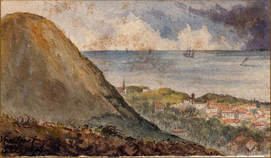
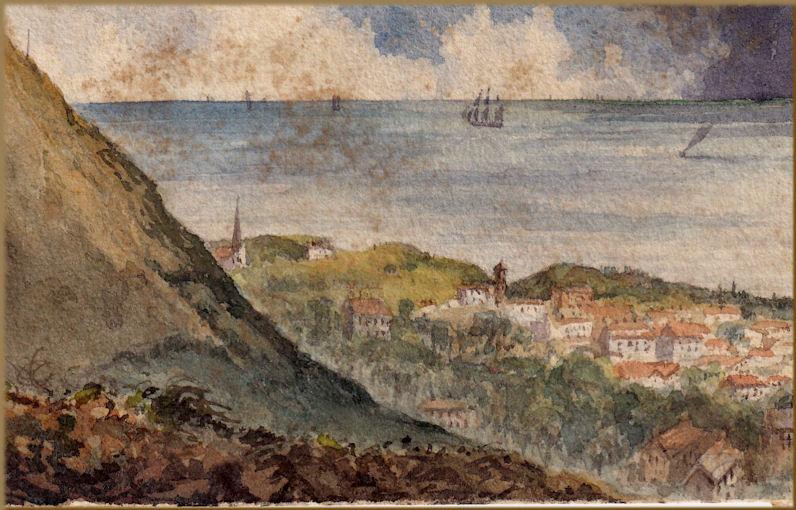
inscribed signed with monogram and dated " Ventnor E.T.L. 1874"
Ventnor is a seaside resort and civil parish established in the Victorian era on the southeast coast of the Isle of Wight, England, eleven miles (18 km) from Newport. It is situated south of St Boniface Down, and built on steep slopes leading down to the sea. The higher part is referred to as Upper Ventnor (officially Lowtherville); the lower part, where most amenities are located, is known as Ventnor. Ventnor is sometimes taken to include the nearby and older settlements of St Lawrence and Bonchurch, which are covered by its town council. The population of the parish in 2016 was about 5,800.
Ventnor became extremely fashionable as both a health and holiday resort in the late 19th century, described as the 'English Mediterranean' and 'Mayfair by the Sea'. Medical advances during the early twentieth century reduced its role as a health resort and, like other British seaside resorts, its summer holiday trade suffered from the changing nature of travel during the latter part of the century.
Its relatively sheltered location beneath the hilly chalk downland and south-facing orientation towards the English Channel produces a microclimate with more sunny days and fewer frosts than the rest of the island. This allows many species of subtropical plant to flourish; Ventnor Botanic Garden is particularly notable. Ventnor retains a strongly Victorian character, has an active arts scene, and is regaining popularity as a place to visit.
While Bonchurch and St Lawrence both have churches dating back to the Norman era, the area in-between that became Ventnor was unremarkable until the 19th century. In Anglo-Saxon times it was known as Holeweia, which by the 12th century had become Holeweye, or hollow way (although possibly the name derived from the Holy Well spring on the downs). By 1617 its name appears as Ventnor, probably named after the family name le Vyntener.
There are indications of Bronze Age settlement, with burial mounds on the nearby downs, and excavations have evidenced small scale settlement in the area during both the Iron Age and the early Roman period. These include middens and palaeoenvironmental deposits at Binnel Bay, Woody Bay, St Catherine's Point and Rocken End. The Isle of Wight was the last part of England to be converted to Christianity, and Saint Boniface is believed to have preached locally in the 8th century. During the 13th century, the area was covered by the manors of Holloway and Steephill, both belonging to the Lisle family.
A 1992 archaeological survey found evidence of a medieval settlement at Flowers Brook, which was referred to in a 1327 subsidy roll as Villata de steple. This area was subsequently incorporated into two farms, with some cottages on the site demolished in 1834. Ventnor watermill, on a site just north of the current cascade, is first mentioned in 1327, was destroyed by fire in 1848, rebuilt by 1853, and demolished in 1875.
In the early nineteenth century, in addition to the mill, Ventnor consisted solely of a few fishermen's huts by the cove, a couple of inns, and a farm. In 1804, it was described by John Britton as a "hamlet...formed by a range of neat cottages chiefly inhabited by fishermen, open to the sea in front, and backed by woods and the high downs". The area was divided between the parishes of Godshill and Newchurch. In 1820 both of the manors (Holloway was then known as Ventnor Manor) were sold to John Hamborough and other building speculators. The spur for expansion was the publication in 1830 of the second edition of physician James Clark's book: The influence of climate on disease.This identified the microclimate of Ventnor and the Undercliff as ideal for people with chest complaints ("nothing along the south coast will bear comparison with it", Clark enthused), at a time when consumption (now known as TB) was a common cause of death.

Thereafter Ventnor developed very rapidly into a town, with numerous hotels and boarding houses targeting sick visitors, particularly during the winter, and a wider range of shops than would be expected for a town of its size (by 1891 it had four chemists). In 1844 Parliament passed an Act "for better paving, lighting, cleansing, and otherwise improving part of the parish of Newchurch, called Ventnor, and for establishing a market therein". However, not everyone was enamoured with the fast-growing town: in 1845, after recounting the positive reviews of others, writer John Gwilliam complained of the "intolerable" summer heat and the chalk dust about the town, concluding that to live there would "be one of the greatest punishments that could be inflicted upon me in the Isle of Wight".
In 1853 the first newspaper on the island, the Ventnor Mercury, was launched (it continued publication until 1985). In 1869 Dr Arthur Hill Hassall opened the Royal National Hospital for Diseases of the Chest in St Lawrence, and many local buildings date from the 1860s, by when the current commercial centre of the town was already substantially developed. The later nineteenth century also saw development aimed at wealthier holidaymakers from Britain and Europe, as British seaside resorts generally became very popular.

The first pier from 1860 was washed away. Breakwaters were built in 1863, and by the following year, a steamer service to Littlehampton connected with trains to London. In 1866 the Isle of Wight Railway reached Ventnor, and in 1870 the iron Royal Victoria Pier was constructed. Subsequent storm damage delayed the full establishment of steamer services until 1888 when they were carrying 10,000 passengers from Bournemouth, Southsea, Sandown and Shanklin. The railway ran a non-stop train from Ryde to Ventnor, named 'The Invalid Express' for the consumptive patients; one train famously completed the journey in a little over twenty minutes.Ventnor became known as 'Mayfair by the sea' for the number of wealthy Londoners who were visiting. In 1887, Bartholomew's Gazetteer described Ventnor as "one of the most popular of English health resorts", with the parish then having a population of 5,739.
By the early twentieth century, Ventnor was a flourishing resort town, with several newspapers, a scientific institute, an extensive library, assembly room, pavilion, various sporting clubs, several churches, an annual regatta and carnival, and a new municipal park. In 1901 its population exceeded 6,000.
The physical fabric of the town was not affected by the First World War, although local businesses suffered from the suspension of the summer and winter resort trade, and its war memorial commemorates the local men who died in the fighting. Ventnor and St Lawrence became receiving centres for wounded soldiers. The summer holiday visitors returned in the 1920s, although the winter health trade never resumed. The town reached its zenith in the 1930s when steam packets operated between Southsea and the town's pier. The Art Deco Winter Gardens opened in 1936/7. The relatively small sandy beach was ideal for bathing, and Victorian era hotels in the town's suburbs and near the sea, such as the Ventnor Towers Hotel, remained popular with tourists.

During World War II, the Isle of Wight became a heavily defended restricted area. The radar station at RAF Ventnor was attacked several times during 1940, and the town itself was also bombed, and again in 1942. By the end of the war 120 buildings in the town had been destroyed and nearly 1,500 damaged, with sixteen fatalities. The holiday trade disappeared and was slow to return during post-war austerity. Nevertheless, by the early 1950s the number of tourists warranted 46 trains scheduled to run between Ventnor and Ryde every summer Saturday.
By the 1960s, the British seaside holiday was facing competition from cheap foreign package tours and the rising popularity of motoring. The railway line to Ventnor West closed in 1952 and to Ventnor station in 1966. The pier, damaged by fire and the elements, had fallen into disuse and was finally dismantled in the 1990s. By the 1980s, according to author Michael Freeman: "The town entered the twilight era that characterised so many English seaside places...[with] crumbling public facilities, boarded up shops, faded lodging houses and hotels, not to mention unemployment". During more recent years, there have been some signs of a renaissance, as its strongly Victorian character came back into fashion, with development of the Haven, re-opening of the Winter Gardens, some new shops and restaurants, a lively cultural scene, and the growth in short break travel.
Governance

Ventnor is within the Isle of Wight parliamentary constituency, with local services provided by the unitary Isle of Wight Council. Ventnor comprises part of two of the council's thirty nine wards, with Wroxall, Lowtherville and Bonchurch taking in the very eastern side of the town, as well as Bonchurch and Upper Ventnor, and Ventnor and St Lawrence covering the town centre and western part of the town, including the Esplanade, as well as St Lawrence. Prior to 1974, the town had its own Urban District Council (formed in 1894), merged into South Wight District Council during that year, as a second tier beneath the Isle of Wight County Council. The district council was abolished in 1995 when the unitary authority for the island was created. Since 1994, a conservation area has covered much of the central area of the town.
Ventnor has a town council that manages various local services, including the park, four car parks, public toilets, and allotments. The Council is responsible for local byelaws, and is consulted by the Isle of Wight Council on matters such as planning and transport. The Town Council has eleven councillors covering four wards, with Ventnor West having six of the councillors, plus separate wards for Bonchurch & Ventnor East, Lowtherville, and St Lawrence. Its coat of arms, displayed on welcome signs by roads into the town, shows Hygeia, the ancient Greek goddess of health, adopted in 1890 to reference its importance as a health resort, surrounded by wild roses referencing the garden isle.
The 'Our Place' project in 2014, led by the Town Council working with residents and local public and private sector providers, identified the priorities for the town as being improved health and wellbeing, a renewed and refreshed economy, and enhanced community capacity. The Council's Strategy Plan, developed in 2016 against the background of reduced funding from Isle of Wight Council for local services and the transfer of new responsibilities to the Town Council, focuses on the need for community inclusiveness, co-operation, influence and sustainability, in order to build the capacity to respond effectively to economic and social challenges.
Geography
Ventnor is on the south-east coast of the Isle of Wight, an island in the English Channel about two miles (3.2 km) off the coast of Hampshire, at 50°36′N 1°13′W. It is 11 miles (18 km) by road south-south-east of the island's county town Newport, and about 100 miles (160 km) south-west of London. Its coastline is dominated by cliff scenery, with the town rising up the steep south-facing terraces between Ventnor Bay and St Boniface Down, which, at 241 metres (791 ft), is the highest point on the island. The town itself extends from the seashore up to the slopes of the downs, with its commercial centre being 45 metres (148 ft) above sea-level; the urban area is contiguous with the neighbouring settlements of St Lawrence to the west and Bonchurch to the east.

There are nearby Sites of Special Scientific Interest at Ventnor Downs, St Lawrence Bank, Rew Down, and the Bonchurch Landslips, as well as the coast west of the town that forms part of the island's largest SSSI between Steephill Cove and Compton Chine. The downs are part of the Isle of Wight Area of Outstanding Natural Beauty. Ventnor beach is one of the island's principal if smaller beaches;[38] there are also small beaches at Bonchurch and Steephill. The Isle of Wight Coastal Path runs through Ventnor. The town has no river, although there are tufa-depositing springs along the downs feeding streams that flow the short distance to the sea, such as one through Cascade Gardens, and another through the park that becomes Flowers Brook.
The tides along the coast are strong, with a tidal range of around 3 metres (10 ft). Three miles off the coast, there is a parallel ridge under the sea rising to within 15 metres (49 ft) of the surface; tidal flows forced between it, and the island have carved out a deep channel known as 'St Catherine's Deep'. Offshore there are 71 recorded sites of shipwrecks, and three air wrecks classified as Military Remains Protected Places. The notable Clarendon wreck occurred just along the coast near Blackgang Chine in 1836, which prompted the building of St Catherine's lighthouse.
The local coastline needs active shoreline management, with one of the longest stretches of naturally-developing soft cliffs along the British coast. Many are now protected by rock armour, large grey boulders imported from Somerset, or east of Ventnor by concrete 'tetrapods', all part of a £1.6 million programme of sea defence work completed in the 1990s. The coast here is also part of the South Wight Maritime Special Area of Conservation, with subtidal reefs that provide important habitats for marine species.
Ventnor is the seventh largest town on the Isle of Wight, with a population of just under 6,000. The nearest town is Shanklin, nearly four miles to the north-east, and the nearest villages are Whitwell and Wroxall, both less than 3 miles (4.8 km) distant.