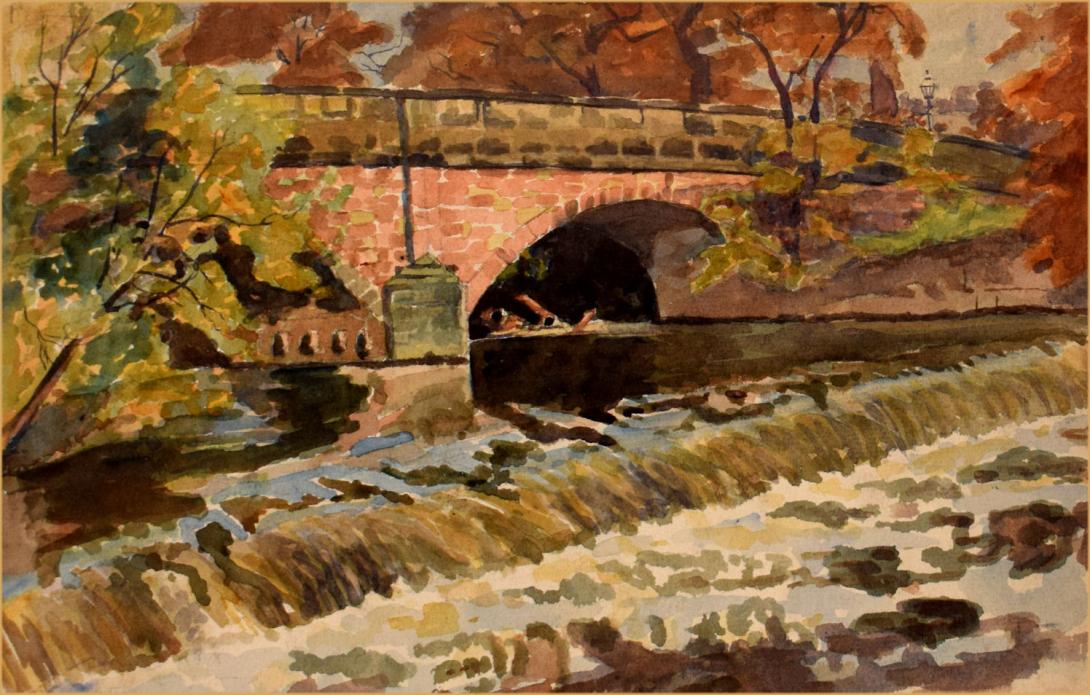
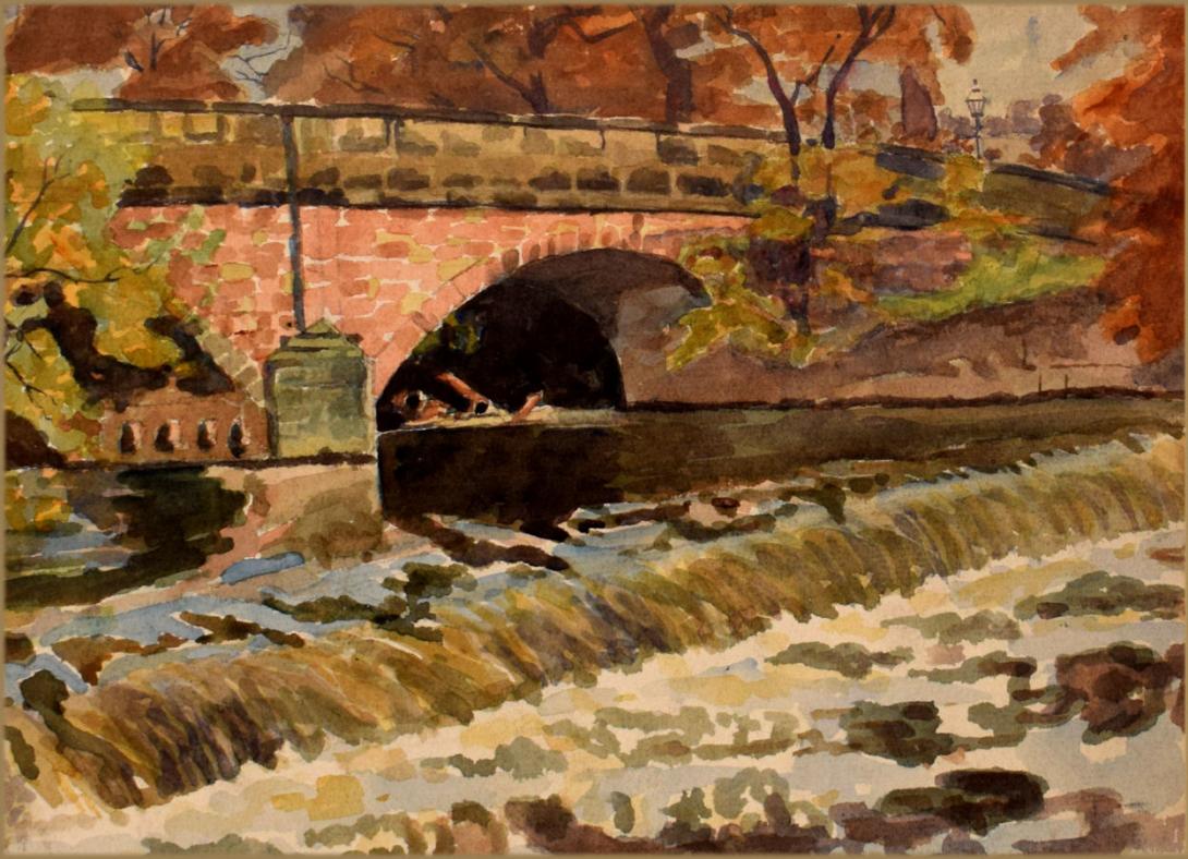
inscribed , dated and signed on the reverse " Otterspool Bridge / Nr Marple / Oct 1930 / A Vincent Reade."
The Original Road Bridge was probably rebuilt after 1606, as there is a stone with the date '1606' on it on the upstream side. the bridge was doubled in width at some point in time with the new part being on the downstream side. Road bridge over the River Goyt. Early C19, widened C20. Red sandstone ashlar. 3 segmental-arch spans with weathered triangular cutwaters. The arches are separated by square pilasters. A band runs at the base of the parapet walls which have stone copings and are terminated in square piers. Widened to the south, but using the same materials and design except for concrete arches.The weir at Otterspool was intended to provide water power for an industrial estate along the banks of the River Goyt.
Romiley is an area of the Metropolitan Borough of Stockport, Greater Manchester, England. Historically part of Cheshire, it borders Marple, Bredbury and Woodley. In Roman times there is thought to have been a settlement along Sandy Lane. At the 2011 census, Romiley ward, which includes Compstall, Bredbury Green and a large part of Bredbury, had a population of 14,139. For centuries it was an agricultural area, until the late Victorian era, when it became a residential area, with a small district centre.
There are four main schools: Romiley Primary School, Bredbury Green Primary, St Christopher's Catholic Primary School and Greave Primary School, which is on the border with Woodley. Secondary education is provided by Werneth School and Harrytown Catholic High School. Romiley also has its own theatre, the Forum Theatre. This is a building owned by Stockport Council but since 2003 has been managed by NK Theatre Arts, a Registered Charity which provides all inclusive performing arts workshops for children, young people and adults. The Theatre is also used by many other local community groups in Stockport.
The surrounds are quite rural, although it is a suburb. There are fields to the north, and Compstall, between Romiley and Marple, is home to the Etherow Country Park, the largest country park in Stockport.
Conservation areas :
Romiley contains four conservation areas, a designation made by the local council to protect locations which have special architectural or historical character. It helps reduce traffic, preserve wildlife and important landscapes, and restricts making changes which affect the look of the area such as changing front doors, roofing, facades or windows.
They are:
Barlow Fold (1997, reviewed in 2006) is around 0.5 miles (0.80 km) to the north east of Romiley town centre and 4 miles (6.4 km) north east of Stockport. The conservation area covers 0.39 hectares and contains 12 households.
Chadkirk (2006) is a quiet rural retreat lying approximately 0.5 miles (0.80 km) south of the centre of Romiley. It comprises farmlands, a 17th-century farmhouse, outbuildings and Victorian walled garden, and a 16th-century chapel, forming an oasis of peace and tranquility, surrounded on three sides by ancient woodlands and the River Goyt which flows alongside.
Church Lane (1996, extended in 2006). Church Lane Conservation Area is essentially a late 19th-century railway suburb, overlaying the lanes and fields of a former agricultural area. It developed as a railway suburb, following the opening of Romiley railway station in 1862. However, it has the form and character of a village or earlier community as the area is focused around the landmark church of St Chad (1864–66).
Greave Fold (1996, reviewed 2006) is 0.5 miles (0.80 km) north of Romiley town centre and approximately 4 miles (6.4 km) north east of Stockport. The conservation area covers 2.31 hectares and contains 48 households.
A further conservation area adjoins Romiley at Hatherlow in Bredbury.
Marple is a small town in the Metropolitan Borough of Stockport, Greater Manchester, England, on the River Goyt 9 miles (14 km) southeast of Manchester, 9 miles (14 km) north of Macclesfield and 4 miles (6 km) southeast of Stockport. In 2011, it had a population of 23,686.
Historically in Cheshire, the town lies along the Peak Forest Canal, containing the Marple Lock Flight and Marple Aqueduct. The Roman Lakes to the southeast of the town centre attracts anglers and walkers. Marple is served by two railway stations, Marple and Rose Hill, providing access to the rail network in Greater Manchester and beyond. It is also close by the Middlewood Way, a cycle path following the former Macclesfield, Bollington and Marple Railway line south from Rose Hill to Macclesfield.
Scientists estimate that the earliest residents of the area settled several millennia ago. There are clues to their existence around the Ludworth area where there are standing stones and tumuli. This was confirmed around 1998 when an archaeological dig in Mellor revealed many clues about the existence of Marple's earliest residents.
The area was predominantly within the Macclesfield Forest, and was omitted from the Domesday Book survey. The first mention of the area was in 1122 in a deed for the sale of land. In 1220 the land passed to the Vernon family where it remained for several generations. The pre-Industrial Revolution inhabitants of the village mostly worked on small farms and others specialised in linen weaving and hatting. After 1790, Samuel Oldknow transformed much of this lifestyle, with the construction of lime kilns and mills. This formed part of the Industrial Revolution. The population of the village began to rise with the construction of terraces to house mill workers and the formation of a village centre filled with private businesses.
Samuel Oldknow also played a large role in the development of the town in addition to his mills; there is still a street named Oldknow Road in Marple today. He built workers' cottages and churches, introduced aspen trees to the area, and assisted in the constructions of the Macclesfield and Peak Forest Canals. Marple Aqueduct, which opened in 1800, carries the Peak Forest Canals over the River Goyt, was designed by Benjamin Outram, a pioneer in the building of canals and tramways. Seven men lost their lives during its construction. Samuel Oldknow died in 1828; his mill was destroyed by fire in 1892. These navigations accelerated Marple's growth, but eventually declined into disrepair when the railway arrived in 1865. They have since been restored for use by leisure narrowboats, now forming part of the Cheshire Ring.
In the early 1900s the town prospered from the success of cotton in nearby Stockport and Manchester; the canals in the area served as a link with other industrial towns. In 1936, Marple Urban District, at the time part of Cheshire, annexed from Derbyshire the parish of Ludworth and Mellor. Marple grew as a residential suburb of Stockport after the arrival of frequent bus and rail services in the 1920s.
The area, close to Derbyshire, covers just over 11 square miles (28 km2) of countryside, ranging from heavily wooded valleys to hill-top moorland. It rises from around 262 feet (80 m) above sea level at the River Goyt to 1,073 feet (327 m) at Cobden Edge. On a clear day it is possible to view the Beetham Tower in Manchester as well as the city centre, the Winter Hill TV transmitter and the surrounding counties of Cheshire, Derbyshire, Lancashire and West Yorkshire and the mountains of North Wales from the top of these hills.
Albert Vincent Reade was born in 1864, he was a portrait, landscape and still life painter. He studied at the Manchester Academy of Fine Arts and Colarossi's Paris, He exhibited between 1901 and 1933 and lived in Manchester.