" P Yates" and inscribed on the reverse
Unframed
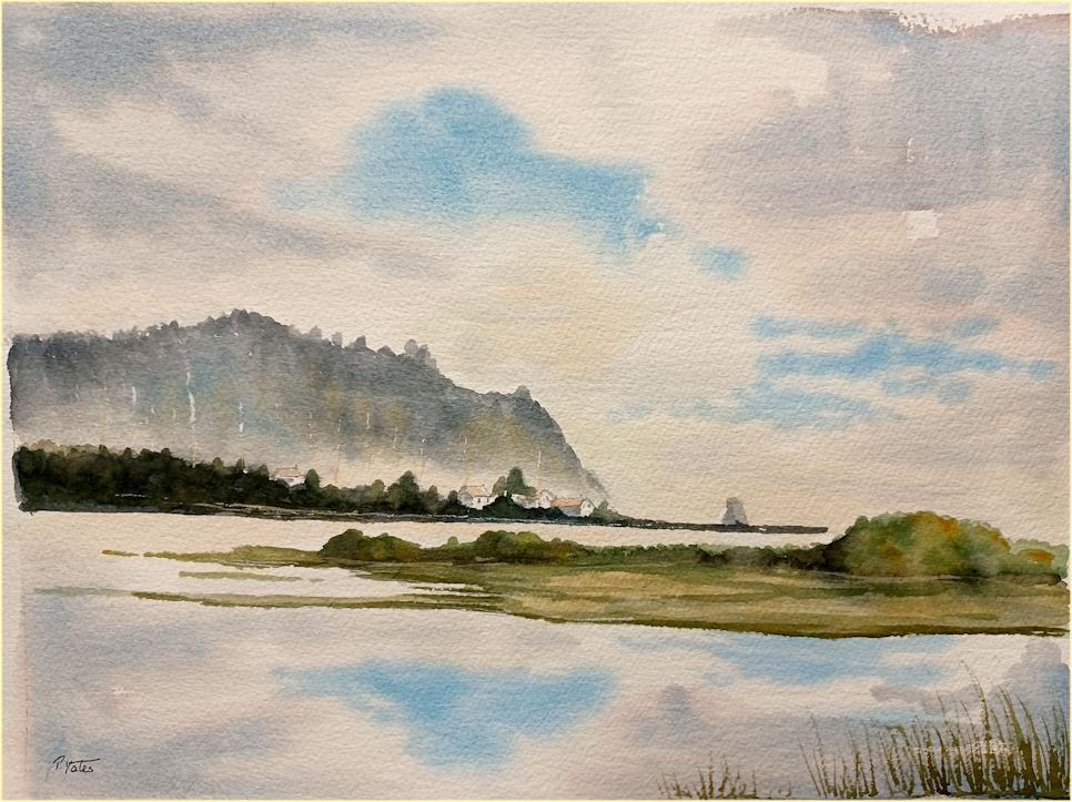
Cape Meares is a small headland on the Pacific coast in Tillamook County, Oregon, United States. The cape forms a high steep bluff on the south end of Tillamook Bay, approximately five miles (8 km) northwest of the city of Tillamook. Much of the cape is part of the Oregon Parks and Recreation Department-administered Cape Meares State Scenic Viewpoint with three miles of hiking trails, which includes Cape Meares Light and the Octopus Tree. The cape is named after John Meares, a British explorer.
Immediately north of the cape is the community of Cape Meares, next to Cape Meares Lake. Cape Meares beach extends north of the community of Cape Meares, along a sand spit, or peninsula, that encloses Tillamook Bay. The peninsula is alternatively known as Bayocean, after a popular upscale resort town that occupied the beach in the early 20th century, until beach erosion began to destroy the town beginning in the 1930s. Today, no significant remnant of the resort town remains on the beach.
Immediately south of Cape Meares is Short Beach.Cape Meares is a sleepy village by the ocean, tucked between a lake and the large bluff of Cape Meares. Surrounded by forest and sea, the area around the town is steeped in tales from the past.
Outside of town in Cape Meares State Park, the compact lighthouse sits on a soaring promontory over the ocean with amazing views for watching both whales and seabirds. Street names pay homage to the now-vanished town of Bayocean, once located on the nearby hiking spot at Bayocean Spit, which became a ghost town and washed into the sea. The surrounding Sitka Spruce forest contains towering trees, as well as the bizarre “Octopus tree.” As day fades, walk the beach, build a campfire, and tell your own stories.
Bayocean was a community in Tillamook County, Oregon, United States. Sometimes known as "the town that fell into the sea", it was a planned resort community founded in 1906 on Tillamook Spit, a small stretch of land that forms one wall of Tillamook Bay.
Bayocean's post office was established on February 4, 1909, and by 1914, the town's population was 2,000.[2] Only a few decades later however, Bayocean had become a ghost town, having had many of its attractions destroyed by "man-induced" coastal erosion. The town's unforeseen destruction is believed by many to have been caused by the residents themselves.Cape Meares the village puts you right into Cape Meares Beach, the long stretch of sand and dunes that quickly becomes the Bayocean Peninsula. But parts of these beach accesses can be extremely narrow, bordered by a high rocky pile that's also covered in massive logs, and depending on sand level conditions there can be little to no beach at all. Winter brings the sand levels down and tides are higher, sometimes making for extremely dangerous conditions the Oregon coast is known for.Bayocean Peninsula Park features a wide, sandy path through all the brush and shrubbery, but it's a long route by foot. It's not the easy access of down at Cape Meares Beach. You're wandering over other dunes and rises, sometimes thinking to yourself “Yay I'm almost there.” Have patience.
Still, it brings you out onto the sandy bluffs and untamed beach of the Bayocean Spit, and along the way to the tip of the peninsula (it's two and a half miles of hiking) there are now little signposts designating the historical spots that once made this spot a sought-after resort.
In fact, the mysteries of the famed Bayocean resort come to life at Bayocean Peninsula Park, now featuring little markers where the town once stood and even signs showing where some of its major landmark buildings sat. These days, hiking here or just taking a stroll can be a lesson in history.
Many don't even know there is also a village by the same name as the much-revered headland. It's a tiny place just west of Tillamook, about 9 miles down the road that skirts along Tillamook Bay, called Bayocean Road.
The location of Bayocean was said to have been discovered by co-founder Thomas Irving Potter while sight-seeing and hunting along the Oregon Coast. It was called by both T. I. Potter and his father/business partner Thomas Benton Potter, who envisioned the venture as the "Atlantic City of the West".Believing the site to have an exceptional view of both Tillamook Bay and the Pacific Ocean, the new town's name was logically derived from both. Bayocean had many features uncommon for a small town of its time, including a dance hall, a hotel with orchestra, a 1000-seat movie theater, a shooting range, a bowling alley, tennis courts, a rail system and four miles of paved streets.One notable attraction was a heated natatorium, complete with a wave generator and a special section for a band to play music to entertain the swimmers.While Bayocean's economy was based on tourism, there were other businesses in town, including a cannery, a tin shop, a machine shop, and a Texaco gas station.In a time when many other towns did not have technological infrastructure like electricity or paved roads, Bayocean hosted a water system, a telephone system and a diesel-driven power plant.Despite having paved roads, Bayocean was not connected to the rest of the country until the 1920s. Most residents and tourists arrived to the town via T. B. Potter's steamship, the S.S. Bayocean, in a three-day trip from Portland.
The final leg of the journey, entering into the unprotected mouth of Tillamook Bay, could provide a rough and frightening experience to passengers. Eventually Bayocean's residents asked the Army Corps of Engineers for a protective jetty to reduce the waves. The Army Corps of Engineers studied the location and suggested that two jetties be built, one on each side of the bay's mouth, at an estimated cost of $2.2 million. Half of that amount was required to come from local residents.[4] With the multimillion-dollar price considered unaffordable, Bayocean's residents proposed and eventually had a single jetty constructed. The price was a little over $800,000 with Bayocean's citizens paying half.[4] Although the new single jetty made for a much smoother journey into the bay, the one-sided change to the coastline began a process of erosion to Bayocean's beaches, slowly narrowing them before overtaking them completely.
In 1932, waves from a massive storm finally crossed the beach and destroyed the huge natatorium. The spit itself was further damaged by winter storms in 1939, 1942, 1948, and by 1952 what was left of Bayocean had become an island.Bayocean's post office closed in 1953. What little remained of the town was demolished during the reclamation and dike-building project of 1956.In 1960, Bayocean's last house was washed away, and in 1971, the last remaining building, a garage, finally fell into the ocean.
With the addition of a second jetty built in the 1970s, sand began to re-accumulate on the spit.The site is now the location of Bayocean Peninsula County Park and virtually all traces of the town are gone. All that remains of Bayocean is a commemorative sign at the south end of the park.