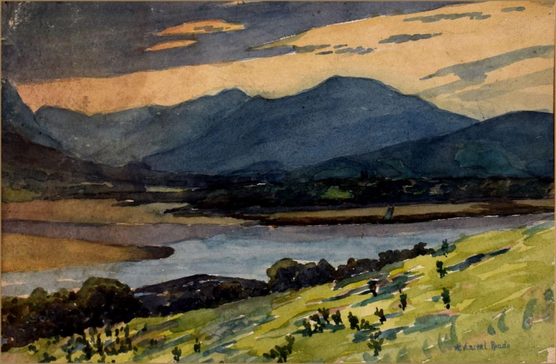
signed "A.Vincent. Reade " and further inscribed dated and signed on the reverse " Welsh Hills from above Beaumaris / Aug 1929 / a Vincent Reade"
Snowdonia (Welsh: Eryri) is a mountainous region in northwestern Wales and a national park of 823 square miles (2,130 km2) in area. It was the first to be designated of the three national parks in Wales, in 1951. It contains the highest peaks in the United Kingdom outside of Scotland.
The English name for the area derives from Snowdon, which is the highest mountain in Wales at 3560 ft (1,085 m). In Welsh, the area is named Eryri. A commonly held belief is that the name is derived from eryr ("eagle"), and thus means 'the abode/land of eagles',but recent evidence is that it means Highlands, and is related to the Latin oriri (to rise) as leading Welsh scholar Sir Ifor Williams proved.
The term Eryri first appeared in a manuscript in the 9th-century Historia Brittonum, in an account of the downfall of the semi-legendary 5th-century king Gwrtheyrn (Vortigern).
In the Middle Ages the title Prince of Wales and Lord of Snowdonia (Tywysog Cymru ac Arglwydd Eryri) was used by Llywelyn ap Gruffudd; his grandfather Llywelyn Fawr used the title Prince of north Wales and Lord of Snowdonia.
Before the boundaries of the national park were designated, "Snowdonia" was generally used to refer to a smaller area, namely the upland area of northern Gwynedd centred on the Snowdon massif, whereas the national park covers an area more than twice that size extending far to the south into Meirionnydd. This is apparent in books published prior to 1951, such as the classic travelogue Wild Wales by George Borrow (1862) and The Mountains of Snowdonia by H. Carr & G. Lister (1925). F. J. North, as editor of the book Snowdonia (1949), states "When the Committee delineated provisional boundaries, they included areas some distance beyond Snowdonia proper." The traditional Snowdonia thus includes the ranges of Snowdon and its satellites, the Glyderau, the Carneddau and the Moel Siabod group. It does not include the hills to the south of Maentwrog. As Eryri (see above), this area has a unique place in Welsh history, tradition and culture.
Snowdonia National Park (Welsh: Parc Cenedlaethol Eryri) was established in 1951 as the third national park in Britain, following the Peak District and the Lake District. It covers 827 square miles (2,140 km2), and has 37 miles (60 km) of coastline. The park is governed by the Snowdonia National Park Authority, which is made up of local government and Welsh representatives, and its main offices are at Penrhyndeudraeth. Unlike national parks in other countries, Snowdonia (and other such parks in Britain) are made up of both public and private lands under central planning authority. The makeup of land ownership at Snowdonia is as follows:
More than 26,000 people live within the park. 58.6% of the population could speak Welsh in 2011.While most of the land is either open or mountainous land, there is a significant amount of agricultural activity within the park. Since the local government re-organisation of 1998, the park lies partly in the county of Gwynedd, and partly in the county borough of Conwy. It is governed by the 18-member Snowdonia National Park Authority; nine members are appointed by Gwynedd, 3 by Conwy, and the remaining six by the National Assembly for Wales to represent the national interest.
Unusually, Snowdonia National Park has a hole in the middle, around the town of Blaenau Ffestiniog, a slate quarrying centre. This was deliberately excluded from the park when it was set up to allow the development of new light industry to replace the reduced slate industry. (There is a similar situation in the Peak District National Park where the boundaries were drawn to exclude large built-up areas and industrial sites from the park with the town of Buxton and the adjacent quarries outside but surrounded on three sides by the park.) The Snowdonia Society is a registered charity formed in 1967. It is a voluntary group of people with an interest in the area and its protection.
Amory Lovins led the successful 1970s opposition to stop Rio Tinto digging up the area for a massive mine.
Snowdonia may be divided into four areas:
The northernmost area is the most popular with tourists, and includes (from west to east) Moel Hebog, Mynydd Mawr and the Nantlle Ridge; the Snowdon Massif; the Glyderau; and the Carneddau. These last three groups are the highest mountains in Wales, and include all Wales' mountains higher than 3000 feet.
The second area includes peaks such as Moel Siabod, Cnicht, the Moelwynion, and the mountains around Blaenau Ffestiniog.
The third area includes the Rhinogydd in the west as well as the Arenig and the Migneint (this last being an area of bog), and Rhobell Fawr. This area is not as popular with tourists as the other areas, due to its remoteness.
The southernmost area includes Cadair Idris, the Tarren range, the Dyfi hills, and the Aran group, including Aran Fawddwy, the highest mountain in the United Kingdom south of Snowdon.
The Berwyn range to the south east, has the western part of it in the park, but the highest summits to the east have been omitted.
Albert Vincent Reade was born in 1864, he was a portrait, landscape and still life painter. He studied at the Manchester Academy of Fine Arts and Colarossi's Paris, He exhibited between 1901 and 1933 and lived in Manchester.