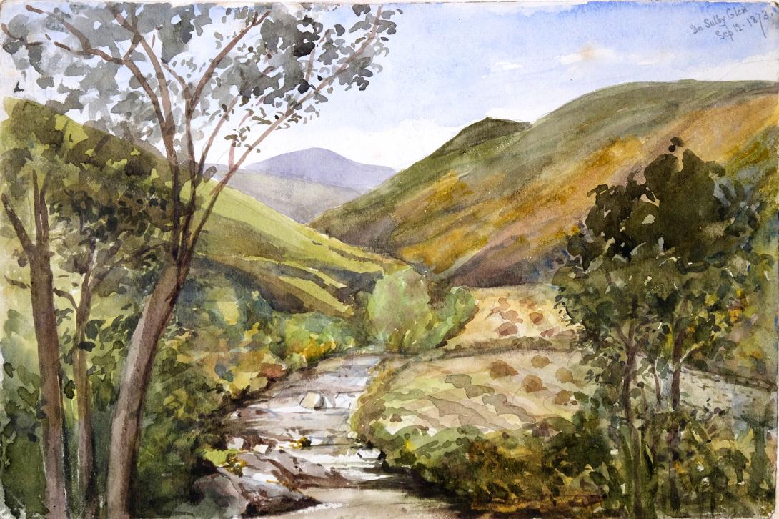
inscribed and dated "In Sulby Glen Isle of Man Sept 12 1873" and signed with initials "LWT"
Tom and Laura Taylor and thence by descent
Sulby Glen is a partly wooded glen in the parish of Lezayre in the Isle of Man. It runs north to south and is about 5 km (3 miles) long. In places the floor of the glen is only 50 metres wide, with steep sides. The Sulby River rises in the nearby Snaefell Mountain foothills and flows through the glen, and it also contains the A14 road. At the top of the glen the river emerges from the Sulby Reservoir (the largest reservoir in the island, created in 1982). At the bottom of the glen, about 1 km south of the village of Sulby, the river emerges into the island's northern plain. By the riverside just below this point is Sulby Claddagh, a local beauty spot and camp site.
A small side valley branching from Sulby Glen near Sulby Reservoir is occupied by Tholt-y-Will Glen, one of the officially-listed Manx National Glens and the only one of these which is located in the mountainous centre of the island. This is managed, preserved and maintained in a semi-natural state by a government agency: the Forestry Amenity and Lands Directorate of the Department of Environment, Food and Agriculture. As at October 2017, access to Tholt-y-Will Glen was restricted due to a damaged bridge. At the entrance to Tholt-y-Will Glen is a small car park and picnic area,
Sulby is a village in the Isle of Man. It is 4 miles from Ramsey and is located in the parish of Kirk Christ Lezayre on the A3 Castletown road.
Historically containing the Treen of the Curragh of Kirk Christ Lezayre and the Land of the Monks of Myrosco, the village is situated at the southern edge of the island's northern alluvial plain; north of the island's northern hills; at the point where the Sulby River emerges from those hills.
The old part of Sulby is situated at the junction between the A14 Tholt-y-Will Road and the B9 Claddagh Road (grid reference SC382940). This part of Sulby has a mill and a village green. The main part of the village is situated along the main A3 road between Close-e-Volley and Ginger Hall, centred on its junction with the A14,
The name Sulby (Old Norse: Sóla-ɓør) ('Soli's farm')), or Súla + bý (farm of the cleft) reflects the Scandinavian influence in Isle of Man place-names. Sulby has a primary school, a hotel and a large campsite in the river meadow of Sulby Claddagh. It also has a post office, general stores, an inn, a Methodist church, and an Anglican church. The village is dominated by the Sulby River, the Ballamanaugh farm estate, common land of the Claddagh and Cronk (hill) Sumark, which includes the remains of a fort from the Iron Age.
The Isle of Man is famous for the Isle of Man TT motorcycle races which are held each June. Sulby Straight is recognised as being the fastest straight on the Isle of Man TT circuit. Sulby village includes the 1.55 kilometres (0.96 mi) Sulby Straight and Sulby Bridge was part of the 37.50 Mile Four Inch Course for the RAC Tourist Trophy automobile races held in the Isle of Man between 1908 and 1922.
In 1911, the Four Inch Course for automobiles was first used by the Auto-Cycling Union for the Isle of Man TT motor-cycle races. This included the Sulby Straight. The course later became known as the 37.73 mile Isle of Man TT Course which has been used since 1911 for the Isle of Man TT Races and from 1923 for the Manx Grand Prix races.
During a practice session for the 2006 Isle of Man TT races, New Zealander Bruce Anstey achieved the unofficial current top speed record of 206 mph (332 km/h) at the end of Sulby straight near the Kella crossroads. This speed value was registered by the on-board data-logging equipment. This unofficial speed record was achieved again in 2015 by the TT competitor James Hillier riding the Kawasaki H2R factory concept bike during a demonstration lap, recorded by onboard Strava data-logging equipment.
The notorious hump-backed Sulby Bridge on the A3 road located at the eastern end of the Sulby Straight (built c.1815), considered at the time to be the most difficult part of the TT Course for motor-cycle competitors, was removed in 1922-23 by the Isle of Man Highway Board. The road was widened and its profile improved.
The Sulby Bridge was originally built in 1739 as a result of the 1739 Bridges Act to improve access to roads in the Isle of Man. The nearby ‘Five Ton Bridge’ over the Sulby river was built in 1935 on the Sulby Claddagh to replace a ford and footbridge damaged in flooding in September 1930. The village of Sulby was previously served by the Sulby Glen and Sulby Bridge railway stations until the Ramsey to St. Johns line closed in 1968.
The Isle of Man is in the middle of the Irish Sea, nestled between Ireland and England. It’s about the same size as Singapore – but with a much smaller population so we get to enjoy plenty of space! Many factors contribute to the beauty of the Isle of Man, from the quaint streets of its historic towns to the breath taking views from the hills.
The Isle of Man’s countryside is often referred to as ‘Great Britain in miniature’ or as The Times recently put it, "It’s like Britain with the ugly bits removed." This comparison is drawn from the Island’s rich landscape which quickly changes from dramatic hilly expanses, to dark and impressive lakes and forests, down to golden stretches of beaches and coves. Despite its compact size, the Island contains a wide variety of scenery. In the north of the Island you will discover long sandy beaches that wrap around the coastline with dunes and lighthouses dotting the shore. The further south you travel the higher the Island rises, with hills, rocky cliffs and sheltered bays.
The Island’s cities and towns are never too far from a dramatic view. The capital city of Douglas boasts a 2 mile promenade of Victorian hotels, trendy apartments and restaurants against a backdrop of glorious sunrises and the iconic Tower of Refuge. It’s easy to move from urban landscape to the middle of nowhere in a short journey, offering the best of both worlds for the Island’s residents.The Isle of Man has a relatively small population and compact towns meaning that light pollution is rarely an issue. Even in the Island’s capital city you can make out the outlines of constellations through the glow of street lamps.
The Isle of Man has an incredible 26 Dark Sky Discovery Sites with the greatest concentration of Dark Sky sites in the British Isles. If you’re lucky you may also spot the Northern Lights! A clear view of the northern horizon from the Island’s north east coast has revealed fantastic displays of this fascinating phenomenon.Due to its variation of landscape, the Island is a walkers’ paradise, with over 169 miles of public footpaths across the Island.
Visitors have come from all over the world to travel the Raad Ny Foillan (English: ‘Way of the Gull’), a 102 mile coastal path skirting the Manx coastline. This walk can be done by experienced hikers in 5 days, but is broken up into 12 sections for easily digestible weekend treks.From beaches to mountains, medieval castles to trendy apartments, wild forests to rolling hills, the Isle of Man is a true natural paradise just waiting to be explored. The Isle of Man is the only full jurisdiction in the world to be named a UNESCO Biosphere.
The Isle of Man is a self-governing British Crown Dependency in the Irish Sea between Great Britain and Ireland. As head of state, Charles III holds the title Lord of Mann and is represented by a Lieutenant Governor. The government of the United Kingdom is responsible for the isle's military defence and represents it abroad.
Humans have lived on the island since before 6500 BC. Gaelic cultural influence began in the 5th century AD, when Irish missionaries following the teaching of St. Patrick began settling the island, and the Manx language, a branch of the Goidelic languages, emerged. In 627, King Edwin of Northumbria conquered the Isle of Man along with most of Mercia. In the 9th century, Norsemen established the thalassocratic Kingdom of the Isles, which included the Isle of Man. Magnus III, King of Norway from 1093 to 1103, reigned as King of Mann and the Isles between 1099 and 1103.
In 1266, King Magnus VI of Norway sold his suzerainty over Mann to King Alexander III of Scotland under the Treaty of Perth. After a period of alternating rule by the Kings of Scotland and England, the island came under the feudal lordship of the English Crown in 1399. The lordship revested in the British Crown in 1765, but the island did not become part of the 18th-century Kingdom of Great Britain, nor of its successors, the United Kingdom of Great Britain and Ireland and the present-day United Kingdom of Great Britain and Northern Ireland. It has always retained its internal self-government. In 1881, the Isle of Man Parliament, Tynwald, became the first national legislative body in the world to give women the right to vote in a general election, although this excluded married women.
The Manx economy is bolstered by its status as a tax haven and offshore banking destination. Insurance and online gambling each generate 17% of the GNP, followed by information and communications technology and banking with 9% each. This status has also brought the problems of money laundering, financial crime, and terrorism financing.
The Isle of Man is an island located in the middle of the northern Irish Sea, almost equidistant from England to the east, Northern Ireland to the west, and Scotland (closest) to the north, while Wales to the south is almost the distance of the Republic of Ireland to the southwest. It is 52 kilometres (32 mi) long and, at its widest point, 22 kilometres (14 mi) wide. It has an area of around 572 square kilometres (221 sq mi). Besides the island of Mann itself, the political unit of the Isle of Man includes some nearby small islands: the seasonally inhabited Calf of Man, Chicken Rock (on which stands an unstaffed lighthouse), St Patrick's Isle and St Michael's Isle. The last two of these are connected to the main island by permanent roads/causeways.
Ranges of hills in the north and south are separated by a central valley. The northern plain, by contrast, is relatively flat, consisting mainly of deposits from glacial advances from western Scotland during colder times. There are more recently deposited shingle beaches at the northernmost point, the Point of Ayre. The island has one mountain higher than 600 metres (2,000 ft), Snaefell, with a height of 620 metres (2,034 ft). According to an old saying, from the summit one can see six kingdoms: those of Mann, Scotland, England, Ireland, Wales, and Heaven. Some versions add a seventh kingdom, that of the sea, or Neptune. Internationally, the Isle of Man is known for the TT Motorcycle Races, and the Manx cat, a breed with short or no tails. In 2016, UNESCO awarded the Isle of Man biosphere reserve status.
Laura Wilson Barker (6 March 1819 – 22 May 1905), was a composer, performer and artist, sometimes also referred to as Laura Barker, Laura W Taylor or "Mrs Tom Taylor".
She was born in Thirkleby, North Yorkshire, third daughter of a clergyman, the Rev. Thomas Barker. She studied privately with Cipriani Potter and became an accomplished pianist and violinist. As a young girl Barker performed with both Louis Spohr and Paganini. She began composing in the mid-1830s - her Seven Romances for voice and guitar were published in 1837. From around 1843 until 1855 she taught music at York School for the Blind. During this period some of her compositions - including a symphony in manuscript, on 19 April 1845 - were performed at York Choral Society concerts.
On 19 June 1855 she married the English dramatist, critic, biographer, public servant, and editor of Punch magazine Tom Taylor. Barker contributed music to at least one of her husband's plays, an overture and entr'acte to Joan of Arc (1871), and provided harmonisations as an appendix to his translation of Ballads and Songs of Brittany (1865).
Her other works include the cantata Enone (1850), the violin sonata A Country Walk (1860), theatre music for As You Like It, (April 1880), Songs of Youth (1884), string quartets, madrigals and solo songs. Her choral setting of Keats's A Prophecy, composed in 1850, was performed for the first time 49 years later at the Hovingham Festival in 1899. The composer was present.
Several of Barker's paintings hang at Smallhythe Place in Kent, Ellen Terry's house.
Barker lived with her husband and family at 84 Lavender Sweep, Battersea. There were two children: the artist John Wycliffe Taylor (1859–1925), and Laura Lucy Arnold Taylor (1863–1940). The Sunday musical soirees at the house attracted many well-known attendees, including Lewis Carroll, Charles Dickens, Henry Irving, Charles Reade, Alfred Tennyson, Ellen Terry and William Makepeace Thackeray.
Tom Taylor died suddenly at his home in 1880 at the age of 62. After his death, his widow retired to Porch House, Coleshill in Buckinghamshire, where she died on 22 May 1905, aged 86.