" P Yates" and further inscribed on the reverse
Lerwick is Shetland's only town, with a population of about 7,500 – although about half of the islands' 22,000 people live within 10 miles of the burgh. Founded as an unofficial marketplace to service 17th century Dutch herring fleets, Lerwick took a long time to grow. Because of its illegal status (and alleged immorality!) the straggling hamlet around the shore of Leir Wick ('muddy bay') was demolished by order of the Scalloway court in 1615 and 1625.
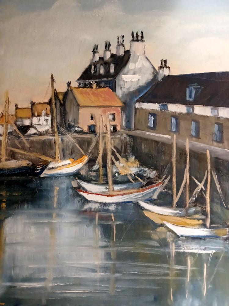
Most of the sandstone buildings on the waterfront date from the 18th century, although a few are older. The narrow main street still follows the old shoreline but modern harbour works have been built out in front of shops and warehouses that once stood in the sea. No-one designed the old town – it just grew – but, up beyond the Hillhead, Victorian architects laid out a "new town" of spacious villas and public parks, dominated by Lerwick Town Hall – a monument to the civic pride of the 1880s.
Lerwick is the main town and port of the Shetland archipelago, Scotland. Shetland's only burgh, Lerwick had a population of about 7,000 residents in 2010. Centred 123 miles (200 km) off the north coast of the Scottish mainland and on the east coast of the Shetland Mainland, Lerwick lies 211 miles (340 km) north-by-northeast of Aberdeen; 222 miles (357 km) west of the similarly sheltered port of Bergen in Norway; and 228 miles (367 km) south east of Tórshavn in the Faroe Islands. It is both the most northerly and the most easterly town in Scotland.[citation needed] One of the UK's coastal weather stations is situated there, with the local climate having small seasonal variation due to the maritime influence. Being located further north than Saint Petersburg and the three mainland Nordic capitals, Lerwick's nights in the middle of summer only get dark twilight and winters have below six hours of complete daylight.
Lerwick is a name with roots in Old Norse and its local descendant, Norn, which was spoken in Shetland until the mid-19th century. The name "Lerwick" means bay of clay. The corresponding Norwegian name is Leirvik, leir meaning clay and vik meaning "bay" or "inlet". Towns with similar names exist in southwestern Norway (Leirvik, Lervik) and on the Faroe Islands (Leirvík).
Evidence of human settlement in the Lerwick area dates back to the Neolithic (4000–2500 BC) and the Bronze Age (2500–800 BC) known from paleoenvironmental records for human activity and the recovery of artefacts, including a stone axe head submerged in Bressay Sound. Iron Age (800 BC – AD 800) settlement is known at the Broch of Clickimin, which was constructed as early as 400 BC. The first settlement to be known as Lerwick was founded in the 17th century as a herring and white fish seaport to trade with the Dutch fishing fleet. This settlement was on the mainland (west) side of Bressay Sound, a natural harbour with south and north entrances between the Shetland mainland and the island of Bressay. Its collection of wooden huts was burned to the ground twice: once in the 17th century by the residents of Scalloway on the western side of Mainland, then the capital of Shetland, who disapproved of the immoral and drunken activities of the assembled fishermen and sailors; again in 1702 by the French fleet.
Fort Charlotte was built in the mid 17th century on Lerwick's waterfront, and permanent stone-built buildings began to be erected around the fort and along the shoreline. The principal concentration of buildings was in the "lanes" area: a steep hillside stretching from the shoreline to Hillhead at the top. Lerwick became capital of the Shetland Islands in 1708, taking over the function from Scalloway. The civil parish of Lerwick had been in 1701 created from a small part of the parish of Tingwall, to which Scalloway still belongs. When Lerwick became more prosperous through sea trade and the fishing industry during the 19th century, the town expanded in 1891 to the west of Hillhead, thereby including the former civil parishes of Gulberwick and Quarff, as well as the islands parish of Burra. Lerwick Town Hall was built during this period of expansion.
Lerwick war memorial dates from 1923 and was designed by Sir Robert Lorimer. The next period of significant expansion was during the North Sea oil boom of the 1970s when large housing developments were built to the north of Staney Hill (located in Lerwick) and to the south (Nederdale and Sandveien).